
Nearly 128 million Americans have smart phones now according to Pew and Nielsen. That is approximately 50% of the US population. Of those numbers, you have a lot of kids under the age of 10 so the %ile goes even higher. I am going to go out on a limb and say if you are reading this blog, you probably either have one or know someone very close to you with one. That’s a pretty sturdy limb.
 |
| OtterBox Defender |
 |
| LifeProof case |

Solunar Tables– Solunar Calendar by Solve the Puzzle A/S
Navigation– Marine&Lakes: US&Canada By Navionics
This app has saved me several times. From boat lanes to topo maps, it has everything I could ever need. At $15, some people balk at the price but to get this chip for a handheld or fishfinder it’s $100. I figure I am getting an 85% discount and who doesn’t love that? If you need to mark those spots where you are slaying fish or mark a route through that mangrove forest, this is your app. Waypoints are limited only by storage and if you have that many waypoints you need to share. With me. Not only do you get regional coverage but anywhere you draw a box around in the US and Canada, it will download all the info. Super sweet for the budget conscious.
Launch Points– ACK Kayak Launch Points 2.0 Pro by Austin Canoe & Kayak
The gang at Austin Canoe and Kayak have just upped your expectations. With an interactive store, kayak launch spots across the US and a social feature you can get all your supplies and info right here. At only 99 cents, the Pro is the way to go. You can search for points based on distance, most liked and set up favorites. While you are at it, submit a launch point or just search the map. If you need a break you can read the ACK newsletter, lookup how to’s or just watch a video. This app is amazing and I am sad I just found it last week.

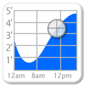 Tides– Tide Graph By Brainware
Want to know when the tide is moving? Checkout Tide Graph. I’ve been using this app for about 18 months and it is very accurate. You can select different points along coast lines and know exactly when the fish are going to be moving. For $2 you won’t have to trust that printed card for accuracy. You can pinpoint where you are going to be and know exactly what’s going to be moving and the rate. If you are fishing in salt even once a year, this will be the best $2 you spend. If you couple this with the solunar table, you’ll find some hungry fish. This isn’t just innovation, it’s information at your hands when you need it.
As I implied earlier, this is not the end all be all list but it has definitely improved my fishing over the time I have had a smart phone with these apps. Learn to read them and the water is your oyster. Open it up and see what you find. Additional apps you find helpful are more than welcome in the comments section and are encouraged.